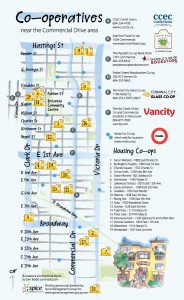
Co-op Map of East Vancouver

The Vancouver Tool Library is very excited to have been included in talented illustrator Sam Bradd‘s map of the co-operatives of East Vancouver.
A group from a number of housing co-ops on the Eastside came forward with the idea and Bradd designed a map that spans from 16th and Clark to Victoria and Hastings. Although the VTL falls just shy of the map’s borders, our little tool-lending library received an honourable mention! We’re proud to be among such great company: 19 housing co-ops, Vancity, modo car co-op, East End Food Co-op, People’s Co-op Books, and CCEC Credit Union, to name a few.
This is an especially opportune time to plot these co-ops on a map, give that 2012 has been declared ‘International Year of the Co-op’ by the United Nations! By supporting co-ops, you’re helping development happen in your community from the ground up. Be involved in the creation and management of the organizations and businesses in your neighbourhood: join a co-op you care about! Spread the word about your local co-ops by telling your friends and family about this handy map.
See the full illustration here: http://www.sambradd.com/co-op-map-of-east-vancouver/.
